Pour la version française du projet GABAR, veuillez cliquer ici : https://ifea-istanbul.net/projet-gabar/
Mission research theme: Surveys of the area around the villages of Güzelyurt, Sivrihisar, and Akyamaç (GABAR)
Site name: Güzelyurt, Sivrihisar, and Akyamaç and their immediate surroundings, Güzelyurt sub-prefecture, Aksaray prefecture, Iç Anadolu province.
Head of the mission: Dr LAMESA Anaïs, University of Edinburgh
Members of the archaeological mission (in alphabetical order for the year 2025):
Lead institution: IFEA
Main funders:
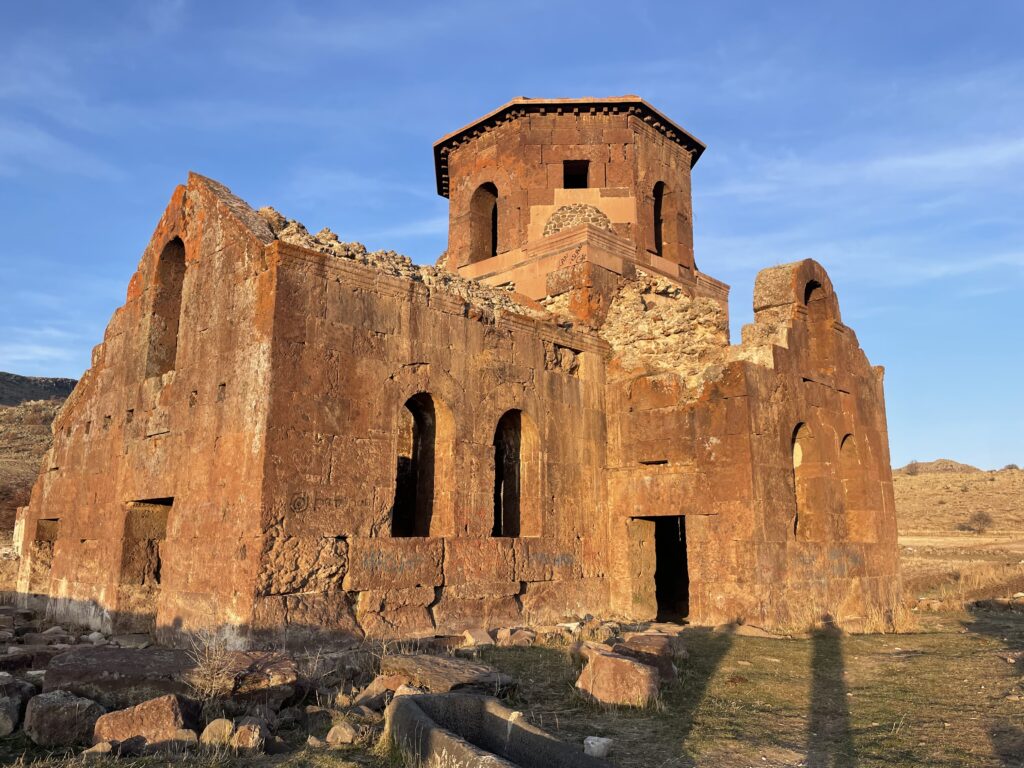
The project LandMarkTurk (Assessing the landscape context to the Red Church (Kızıl Kilise), Western Cappadocia) was awarded by the BIAA small grant scheme.
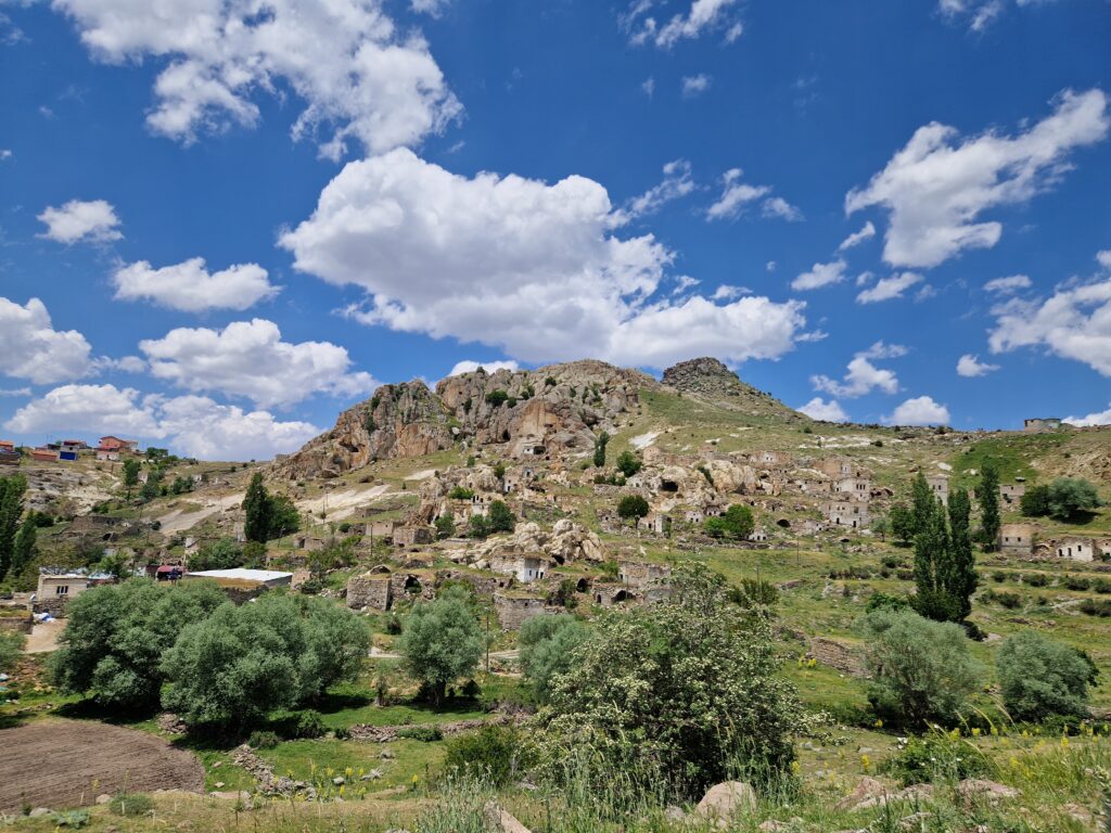
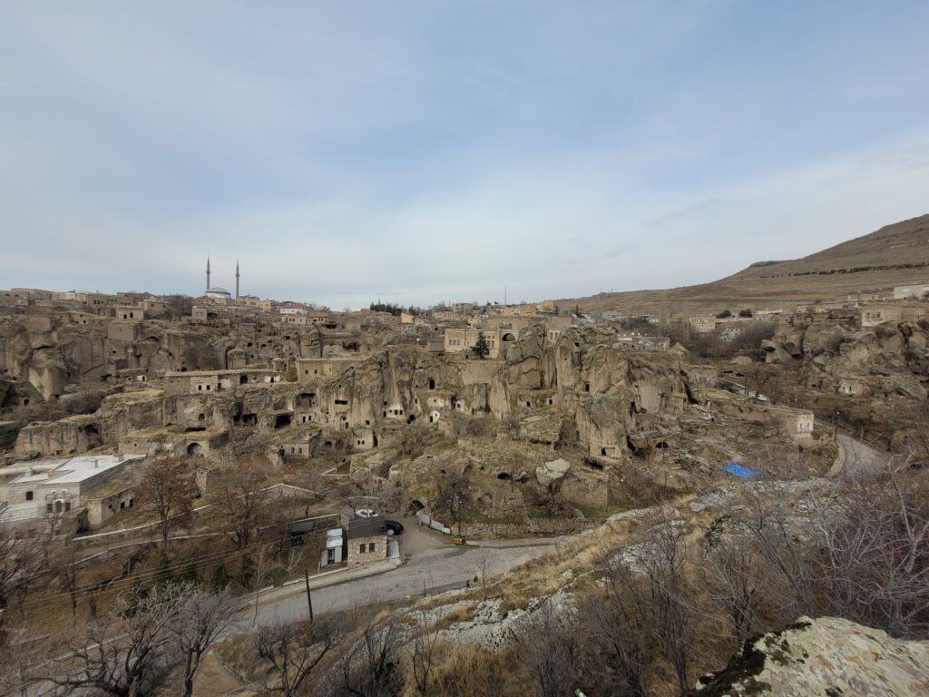
The project will quantify human-environment interaction in the rural landscape of the village of Sivrihisar and the Red Church (Kızıl Kilise) in Cappadocia – a region that remains comparatively understudied within Central Anatolia – by providing dates for agricultural terraces and earthworks that relate to the establishment of the settlement. The site, characterized by dense ceramic scatters, terrace systems and earthworks, appears to have been occupied from Late Antiquity through the Byzantine period, reflecting long-term rural habitation. The project will be co-ordinated by Tim Kinnaird (PI, University of St Andrews), with colleagues from the universities of Newcastle, Nevşehir Hacı Bektaş Veli and Çukurova, and is set within the international GABAR Programme directed by Anaïs Lamesa (University of Edinburgh).
The integration of GIS-based landscape analysis, ceramic analysis and optically stimulated luminescence (OSL) dating will provide a spatial and temporal framework for construction of agricultural features in the landscape of the settlement, therefore elucidating on the foundation of the village and other key events in the landscape history. OSL dating, coordinated by PI Kinnaird, co-Is Turner and Balcı—will provide absolute dates for the construction and utilisation of the terraced slope. In parallel, the ceramic study directed by co-I Jackson, will establish a typological and chronological framework based on diagnostic forms, fabrics, and surface treatments. Comparative analysis with regional corpora will help identify patterns of local production and distribution. Field survey and sampling will be undertaken in 2026, with subsequent laboratory analyses conducted at the University of Çukurova directed by Prof. Aysel Kayış Topaksu (Adana). The integration of archaeological and geoscientific data within the GABAR GIS platform will yield a refined understanding of the settlement’s development, its relationship to the Red Church, and its role within the broader Sivrihisar valley landscape.
By providing the first absolute chronology for this rural site, the project will clarify connections between religious, domestic, and agricultural spaces in Cappadocia. A new methodological model with be established, combining archaeological survey with scientific dating techniques to interpret complex rural environments and contribute to a wider discussion on settlement and land-use practices in central Anatolia from Late Antiquity to the Middle Ages.
The GABAR project is built around several collaborations with Turkish (Nevşehir University, Istanbul University, Aksaray University), British (Edinburgh University), and Portuguese (University of Minho) institutions.
For the 2024-2025 academic year:
– A monthly research seminar was organized: Cappadocia Making seminar series.
Hosted at IFEA, this seminar was conducted in partnership with the University of Edinburgh and UKRI, the University of Nevşehir, and the Laboratory for Rhetoric Studies. It was led by Anaïs Lamesa, Ayşe Budak, Grégoire Sommer, and Idil Üçbaşaran.
This seminar follows on from a previous seminar held in 2011 and 2012. This year, its objective was to explore the landscapes of Cappadocia. The aim was to examine the interplay between tangible and intangible landscapes, as evidenced by archaeological, geographical, and historical sources. A roundtable discussion was held in Güzelyurt itself during the seminar.
– During the 2025 mission, two workshops, open to all, were offered: the first on ceramic design led by Dr. Kudret Sezgin and the second on 3D modeling by Dr. Paulo Bernardes.
The survey area is located in western Cappadocia (Aksaray Province), east of the Melendiz Çayı River, the area’s main waterway. The research focuses on the town of Güzelyurt and the villages of Sivrihisar and Akyamaç.
Güzelyurt is a sub-prefecture built on two rocky promontories oriented northwest/southeast. These two hills are separated by a deep valley that splits into two branches to the south. The western branch is known as the Manastır vadisi (Valley of the Monasteries). In this narrow valley, numerous structures are carved into the rock, some of which are painted churches, commonly dated to the Byzantine period. To the east of the town lies a plain, where several rocky hillocks appear to have been inhabited as early as Roman times. Between the main hill where the modern Yüksek church stands and the town, a dam was built between 1991 and 1995 with a reservoir, the Güzelyurt gölet (the small lake of Güzelyurt).
North of Güzelyurt lie the foothills of Şahinkalesi Tepe, where the village of Akyamaç is located. Akyamaç now has an Orthodox church that has been converted into a mosque.
Starting southeast of Güzelyurt, following the valley that forms the northern boundary between the two promontories and skirts the foothills of Şahinkalesi Tepe, one arrives at the former village of Sivrihisar, built primarily into the rock and now abandoned. North of this village, a dam known as Sivrihisar göleti (Sivrihisar Lake) was constructed between 2013 and 2014.
Continuing along the valley, one reaches a plain where the Kızıl Kilise church stands, the only medieval church in Cappadocia that still retains its dome.
Along with the fortress that overlooks all the valleys and plains of the area, perched on a rocky outcrop between Akyamaç and Sivrihisar, the Kızıl Kilise church is one of the main landmarks of the landscape.
We will not provide an exhaustive list of the research conducted around the three villages.
Among the key travelers, it is important to note the visit of Francis Ainsworth at the end of April 1839. Ainsworth was the first European traveler to mention the town of Güzelyurt and the village of Sivrihisar, and to make a sketch of the Sivrihisar kale[1]. Gertrude Bell, who stayed in the town of Güzelyurt from July 10 to 12, 1907, studied the church of Kızıl kilise and the rock-hewn church of Hagios Ephthemios (present-day Kaburlu kilise)[2].
The main work carried out after the Second World War was by Jacqueline Lafontaine-Dosogne and Nicole Thierry. They are responsible for the first inventory of painted churches in the Hasan Dağ area[3].
In the 1990s, Sacit Pekak compiled the most comprehensive inventory of Byzantine and Ottoman-era churches in the village of Güzelyurt.[4]. Pekak described 27 churches and a rock-cut mosque. Eugenia Equini-Schneider and Marcello Spanu (both members of the Cappadocia mission led by Equini-Schneider) published data on kale and the first inventory of rock-cut tombs in the area.
Finally, in the 2000s, several excavations were carried out at Güzelyurt and around Kızıl Kilise, under the direction of the Aksaray Museum. A short report on the excavations undertaken at the foot of Yüksek Kilise was published by Fatma Sevil Gülçür[5] and for the excavations around the Kızıl kilise in the work of Sema Doğan[6].
Reference notes:
[1] Ainsworth 1840, 300-302.
[2] Bell 1909, 376-382.
[3] Lafontaine-Dosogne 1963, 171-181; Thierry 1963, 24-25.
[4] Pekak 1993 ; Pekak 1994.
[5] Gülçür 2008 ; Gülçür 2009.
[6] Ağaryılmaz, Köröğlu, Kiper 2008, 64-71.
kiliseleri 2. Hacettepe Üniversitesi Edebiyat Fakültesi Dergisi 11/1-2, pp. 177-216.
Thierry 1963 : N. et M. Thierry, 1963. Nouvelles églises rupestres de Cappadoce, Région du Hasan Dağı. Paris : C. Klincksieck.
The first survey mission was carried out in June 2025. Data analysis is currently underway.
The first part of the mission was dedicated to intensive surveys around the Kızıl Kilise church, where more than 4,000 pottery shards were collected. During this survey, two fragments of a blue-tinted glass bracelet and a Seljuk-era coin were collected and deposited in the museum.
The second part of the mission allowed for the initial mapping of the archaeological area: 37 churches (rock-cut, built, and mixed), 35 remarkable rock-cut chambers (vaulted, with sculptures or significant architectural elements), 15 funerary structures, and 2 complexes that may have had a military function were identified. Two reused inscriptions were photographed, and a ceramic miniature hand was deposited in the museum.
X : 34.36960152864706686/ Y : 38.27667384649446802